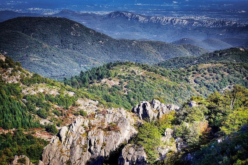
"The granitic peaks [of Mont Lozère] offer a picturesque landscape of vast expanses of grassland, moorland dotted with granite chaos and peat bogs. On the slopes, woodlands (old beech or conifer plantations) become denser, and cultivated areas are concentrated around isolated farms and hamlets. Ash trees grow in clusters or in rows along the edges of houses.
Finally, in the valley bottoms, which mark the boundary between schist and granite, villages and communication routes are concentrated. Here, woodland predominates, and chestnut trees are making a comeback."
At the heart of a perceived territory
Whatever spaces we live in, we inhabit them with our history, the history of our encounters, perhaps that of our ancestors and ghosts. These landscapes inhabit us and make us. Between them and us, there's a kind of breathing space: something in common and a distance.
More classically, the 2000 European Landscape Convention defines landscape as"a part of a territory as perceived by people, whose character results from the action of natural and/or human factors and their interrelationships."
At every moment, we experience our landscapes simultaneously with other human beings. We also share other temporalities with other people. These people were with us at a particular school, have experienced these fields, these forests, this monument. Some social networks are full of nostalgic pages about shared eras.
One or more reference states?
In this way, certain moments and states can become real reference points that we absolutely must preserve or rediscover. All the more so when it comes to landscapes that are important to human beings, such as protected natural sites or remarkable buildings and towns.
Clémence Moreau 's research focused on Mont Lozère, a French massif in the Cévennes region, whose landscape is described at the start of this article. On this protected territory, classified as a Unesco World Heritage site, forests and more open landscapes have fluctuated over 2000 years.
What would be the reference state of such a landscape? What's the basis for determining it? Why should we want to return to it?
Devalued closed spaces
For the more recent period, we provide a summary map of landscape dynamics between 1970 and 2000 (page 64). It shows the rapid (dark red) or moderate (light red) progression of forested areas.
These are referred to as closed areas, with the implicit idea that they determine a landscape of lesser quality. The reference state would correspond to minimum forest cover and maximum agricultural use.
"The increase in forest cover has gradually built up as a problem raising demographic, sociological, ecological and political issues."
The "closure of landscapes" is linked to the"agricultural abandonment" of the rural exodus and industrial development. Abandoned land is first occupied by pioneer plant species, then by shrubs and trees: wasteland, moorland and finally woodland.
Promoting open spaces
Institutionally, open spaces have been promoted in various landscape management and protection plans. But which open spaces are we talking about? Haven't they also been transformed by the intensification of agricultural practices?
Open landscapes are agro-pastoral areas, i.e. they involve both agriculture and livestock farming. Like other agricultural areas, they have evolved towards greater mechanization and productivity, and the concentration of farms. Sheep rearing has declined in favor of cattle rearing.
Thespecificity of the mountains, and of the Cévennes massifs, lies in the presence of permanent grasslands (for the production of herbaceous plants) and "parcours" (used for grazing). These uses are not very intensive and are tending to diminish. Farmers sometimes use very large machinery to remove rocks from the meadows (known as "dérochage", after administrative authorization), which are then turned over for cultivation.
The persistence of a dynamic space requires transformation
"When the state of reference refers to an anthropized landscape, it is no longer the balance of nature that is emphasized, but a harmonious relationship between societies and their environment [...]."
Mont Lozère has a landscape dynamic with a dual temporality: the slow, natural dynamic of increasing forest cover and the rapid dynamic of the evolution of open landscapes, the results of which will be visible in the long term.
From this point on,who decides on the state of equilibrium of the landscape, and on the basis of what representations?
To shed light on this question of stakeholder representations, the sociologist has compared, from a constructivist perspective, the notion of reference state and the ecosystem services perceived by stakeholders.
The notion of ecosystem service also has the character of a frontier object, enabling interdisciplinary exchanges such as dialogue between scientists and managers, and encouraging concerted choices.
A role-playing game has been designed around an expressed need for concerted action: stubble removal and grassland turnovers.
The plurality of landscape legitimacies
139 perceived ecosystem services (positive and negative) were listed among the people surveyed: 46 people, including 39 men and 7 women, local workers from all sectors (under-representation of women and absence of secondary residents).
Four representations emerged, grouped into two main types:
- Those who share the diagnosis that landscape closure is problematic, that it signals the end of peasant society and the breakdown of a balance. The reference point is the middle of the 19th century. Rangelands and permanent grassland are valued.
- People who wish to reopen closed spaces, and maintain a sufficient population by maintaining extensive farming practices, grazing and transhumance.
- People who wish to maintain open spaces and intensify them, mechanize, derive, irrigate.
- People whosee the increase in forest cover as an opportunity. With two ways of taking advantage of it:
- People who promote the use of forests as a "socio-system that can be exploited and thus create jobs". For them, the solution to agricultural decline is to replace one economic sector with another. Wood outlets: timber, firewood and pulp.
- People who see it as an enrichment of biodiversity. The reference state is the maximum forest, a period prior to the agricultural development of the area (Middle Ages). For them, the aim is to encourage the maturation of woodlands, the presence of dead wood, mixed stands and native species.
Quotes to ponder
The words of a dairy farmer:
"For milk, it's better to have artificial grassland than natural grassland, because there are legumes in it."
And the words of an urban tourist, for whom nature "offers a service" of well-being and calm:
"It comforts us to see that nature still exists, that it hasn't completely disappeared yet."
Image source: Albrecht Fietz, on Pixabay.
Read more:
Clémence Moreau, Mettre en débat l'état de référence. Analyse des représentations des dynamiques paysagères au prisme des services écosystémiques : l'exemple du Mont Lozère, 2019, Ecology and Biodiversity, University of Montpellier.
Thesis available at: https: //www.theses.fr/2019MONTG004
See more articles by this author