Is collective resilience possible?
Since the dawn of time, we have built our lives around myths. What about today's ecological narrative? Will it succeed in supplanting the dominant mercantile narrative?
Publish at December 19 2025 Updated December 19 2025


How could a continent with a surface area of almost 5 million square kilometers, larger than India or almost two-thirds the size of Australia, remain absent from maps and ignored by the scientific world?
It's because it's 95% submerged and, as a result, its boundaries have remained undefined or falsely integrated into the Australian continent. What geological researchers have finally been able to demonstrate is that it is indeed an independent continent, including New Zealand, the Chatham Islands and New Caledonia, among others. They have dubbed this continent "Zeelandia".
There are a few microcontinents, fragments of continental crust detached from the main continent by plate tectonics, often submerged and surrounded by ocean. There are also plateaus, continental extensions that extend under the sea to the limits of a tectonic plate, but a continent is something else.
A continent is a mass with a continental crust, a tectonic structure and a geological lineage dating back to Gondwana, the supercontinent that grouped Africa, South America, Australia, India, Antarctica and Madagascar, formed around 600 million years ago and fragmented during the Jurassic era, around 160 million years ago. The traces left by the movements and transformations of this super-continent allow us to go back in time and determine the filiation of a continent with Gondwana.
In 2017, researchers aboard the International Ocean Discovery Program vessel carried out six drilling missions in the presumed submerged territory of Zelandia. The sediment cores they recovered, some more than 1,250 meters deep, included microfossils, pollen grains and signs of shallow marine environments. These elements can only come from continental crust, not just fragments of oceanic crust.
Using geological samples from the seabed, including basalt, the researchers were able to map and date the main geological units of Zelandia, confirming that these territories were not always underwater, and may even have once been home to terrestrial life before being engulfed. Various chemical analyses and even anomalies in the Earth's magnetic field have also enabled researchers to identify more precisely certain tectonic plate boundaries and determine their independence.
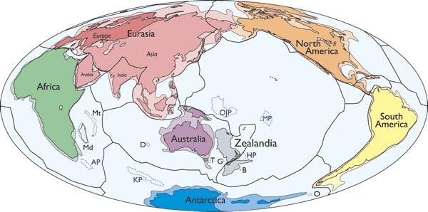
These discoveries place Zelandia on a par with other continents in terms of geological complexity and tectonic history. The fact that Zelandia is submerged in no way diminishes its geological importance.
There are many reconstructions of the territory around Australia, using geological similarities. However, on a continental scale, most use rigid reconstructions that feature exaggerated and unrealistic bulges at the boundary between the Gondwana paleo-continent and the ocean, as well as inconsistent offsets and faults between blocks.
This new continent brings greater coherence to explanations of geological formations in this part of the world.
Illustrations: Shutterstock - 787337128 and Geosociety
References
Reconnaissance Basement Geology and Tectonics of North Zealandia - Nick Mortimer, Simon Williams - AGU - Tectonics - "95% submerged Zealandia continent has now been outlined in reconnaissance."
https://agupubs.onlinelibrary.wiley.com/doi/10.1029/2023TC007961
Vanished for 375 Years, "Zealandia" Earth's 8th Continent Has Finally Been Found Beneath the Pacific Ocean
https://indiandefencereview.com/vanished-for-375-years-zealandia-earths-8th-continent-has-finally-been-found-beneath-the-pacific-ocean/
Note on the Geology of the Outlying Islands of New Zealand - Sir James Hector - 1895 - Transactions and Proceedings of the Royal Society of New Zealand
https://paperspast.natlib.govt.nz/periodicals/TPRSNZ1895-28.2.7.1.10
You might also like:
Is collective resilience possible?
Since the dawn of time, we have built our lives around myths. What about today's ecological narrative? Will it succeed in supplanting the dominant mercantile narrative?
What education can learn from the automotive industry
If we compare it to the automobile industry, education has almost become its opposite... And yet, the purpose of both is to transport or teach, in order to help society AND its citizens achieve their goals.
Contemporary Native American Fiction and the Reinvention of the Self [Thesis].
The novels of four Amerindian authors outline the solutions provided by literary totemism for the reinvention of identities in a dynamic and resolutely transmutatory modality. Whoever you are, and certainly for different reasons, you will be able to identify with the heroes of this literature and feel the strength of a great renewal.
Digital cultural planning: with the public.
Planning an audience engagement strategy using digital tools is anything but a simple undertaking. Two authors have published a practical guide online to help with this planning in cultural institutions, a guide that could probably be adapted to other fields.